River transport in Eretald

Almea and the Incatena
sasasha
Posts: 468
Joined: Mon Aug 06, 2018 11:41 am

Re: River transport in Eretald

Post by sasasha »

I've got so many things to say on this subject for some unknown reason! :P But I can't spend much more time on it right now, I've been fairly obsessed with it all for days and probably need to do some other stuff for a bit. Thank you both so much for all your extremely helpful comments ‒ which, don't worry, I have heard ‒ I'm glad you like the drawings zomp, and I'll come back to this properly in a few days if I can.

I think I want to leave all this (for now) with the following general point.

If you are in the business of trading over rivers, and you have the means, you go to the best possible market for your goods. That's a product of market availability and your ability to get there (including what you might miss out on by going). For some, that might just be the other side of the river. For a number of early medieval trading groups from the east of Sweden, that meant Constantinople ‒ a much more difficult destination than Verdúria is for our 35th century Cereians.

The Varangian trade seems unlikely, but it produced its own infrastructure. We don't know exactly much of what that infrastucture consisted of then (ships, portages, food supply networks, agents, etc etc), but we sure know what it turned into: several modern nations ‒ including the largest on Earth.* That's a bit more of a complex and impressive legacy than a potential development in the history of scheduling.

The point is, people do things to travel long distances for trade that don't necessarily seem rational, because they believe they can probably make good out of it. And often, where there's a will, there's a way ‒ and they make it easier for themselves or someone else to do it next time. This process frequently drives social and cultural development.

I get the feeling that we're reducing this discussion a bit much to describing ‘what is normal’. That's part of what I want to use this thread to help define; but there's also the marginal, the unexpected, the surprising things people will do when they're desperate or frustrated or filled with a dream or conviction (which may or may not be founded).

As someone who likes stories I often gravitate to the latter ‒ the marginal ‒ and that's not to say I don't also have an appreciation for establishing ‘what is normal’. But people's behaviour will always seep through those bounds and establish things that previously seemed unlikely.

I want to be clear I'm not making any argument for ‘my boat’ and the operational model I've suggested! I hear the Word of God :D I got the scale way off wrt the number of people who'd fit on a vessel like this (as zomp suggested the other day, I wasn't visualising it right). Ditto, I think, the number and regularity of journeys in this period. But I must say a lot of this is based on a bit of a miscommunication: I absolutely never saw the ‘schedule’ as I created it to be ‘binding’. It's just that the river has a speed, and if a few passengers are going to hop on, then they're going to want a rough idea of how long it's going to take them to get somewhere. The schedule itself began as a diagram for me to try to work out how long it might take to get from place to place, and I'm not seriously suggesting it would be used as a commercial document (‒ for a start, who would print it, why and where?). If it were, as zomp said, it would be purely aspirational. The word schedule gives the wrong impression of what I was doing creating and presenting it ‒ I am trying to establish how river travel works in Eretald, not trying to schedule it! :)

Once again, thanks for the discussion, as I think we're all closer to understanding this deeply!


(*Trying to find ways to put this point sensitively today is difficult; I apologise if I have failed to do so!)
Glenn
Posts: 43
Joined: Wed Feb 15, 2023 6:40 am

Re: River transport in Eretald

Post by Glenn »

Raphael wrote:Now I wonder, when and why did the robbers along major roads that were so notorious about 300-200 years ago disappear?
A glance at Wikipedia, et al offers some possible explanations:

- Increased policing of the roads by state agencies.

- The expansion of manned toll roads with restricted access.

- Increased access to firearms by ordinary citizens (in other words, the robbers may be armed, but coach drivers and passengers might also be armed, and better able to fight back).

- Increased population density (translating to fewer lonely roads and more witnesses)

- Greater use of paper banknotes as opposed to coins, with the former being easier to trace.

One theory that surprised me is related to the enclosure movement in English, especially the Inclosure Act of 1773, which led to more landowners closing off formerly common land with stone walls to serve as grazing land for sheep; it’s harder to spring out of hiding and ambush somebody if you have to climb a stone wall in the process. In addition, the overall political and economic situation may play a role (highway robberies may be greater in times of instability, unrest, and civil war, or in the wake of war, as former soldiers turn to other armed occupations).

I have been following this thread with interest; Kiarlon, the con-country that I have been poking (mostly unsuccessfully) at for many years, also occupies the basins of two large rivers, and I imagine riverboats as playing a major role in travel and economic activity there as well (as well as having The River, and possibly the contrast between The River and The Land, possibly play a large role as a metaphor in philosophy and religion.)
User avatar
Raphael
Posts: 4551
Joined: Sun Jul 22, 2018 6:36 am

Re: River transport in Eretald

Post by Raphael »

Thank you, very informative!
sasasha
Posts: 468
Joined: Mon Aug 06, 2018 11:41 am

Re: River transport in Eretald

Post by sasasha »

A quick question for zompist: the Eärdur is said to be 3km wide at Pelym and needs to be crossed by ferry. Only 20km upriver, at Anaseri, there is a bridge (by 3480).

I'm curious about this bridge ‒ when does it date from? Does the river narrow a lot here (which surely would make a bridge with arches harder to build, as the river would be deeper)? Can big boats pass underneath?

Some briefly researched models to chew on... The Congo remains narrow towards its mouth ‒ but is more than 600 feet deep in parts. 18th century bridges on the Ganges seem to have peaked at a couple of hundred metres (using quite narrow arches all the way along). Trajan's Bridge is probably a good model? Or the Bridge at Arelate?
zompist
Site Admin
Posts: 2944
Joined: Sun Jul 08, 2018 5:46 am
Location: Right here, probably
Contact:

Re: River transport in Eretald

Post by zompist »

sasasha wrote: Sat Feb 17, 2024 5:29 am A quick question for zompist: the Eärdur is said to be 3km wide at Pelym and needs to be crossed by ferry. Only 20km upriver, at Anaseri, there is a bridge (by 3480).

I'm curious about this bridge ‒ when does it date from? Does the river narrow a lot here (which surely would make a bridge with arches harder to build, as the river would be deeper)? Can big boats pass underneath?
I may have to revisit this, but I imagine the Svetla as pretty wide. The Mississippi has an average width of 2 mi (3 km), so 1 to 3 km seems like a good guess.

The Caďinorians could build as well as the Romans, so I imagine they bridged the river at several points. Some but not all of them would have collapsed in the Dark Years.

The bridge in 3480 Anaseri is likely to be a Verdurian construction.

You could certainly get barges and coroni under the bridges. If you have a really big mast... well, maybe it has to be lowered. I'm not sure how this was done in earthly history...
sasasha
Posts: 468
Joined: Mon Aug 06, 2018 11:41 am

Re: River transport in Eretald

Post by sasasha »

zompist wrote: Sat Feb 17, 2024 6:34 am
sasasha wrote: Sat Feb 17, 2024 5:29 am A quick question for zompist: the Eärdur is said to be 3km wide at Pelym and needs to be crossed by ferry. Only 20km upriver, at Anaseri, there is a bridge (by 3480).

I'm curious about this bridge ‒ when does it date from? Does the river narrow a lot here (which surely would make a bridge with arches harder to build, as the river would be deeper)? Can big boats pass underneath?
I may have to revisit this, but I imagine the Svetla as pretty wide. The Mississippi has an average width of 2 mi (3 km), so 1 to 3 km seems like a good guess.

The Caďinorians could build as well as the Romans, so I imagine they bridged the river at several points. Some but not all of them would have collapsed in the Dark Years.

The bridge in 3480 Anaseri is likely to be a Verdurian construction.

You could certainly get barges and coroni under the bridges. If you have a really big mast... well, maybe it has to be lowered. I'm not sure how this was done in earthly history...
Thanks! I've found a 14th century bridge that manages about a kilometer, is still standing, has a very high clearance (because of the topography) and is rather pretty: Pont-Saint-Esprit. And Trajan's Bridge was over a km... so I reckon if the river happens to be about 1km wide at Anaseri, it's reasonable to expect a bridge there. (The river could always widen out again on either side; I think they often narrow a bit at bends.)

I think you could add it to a list of tourist attractions in Eretald, though! It would no doubt be impressive.
sasasha
Posts: 468
Joined: Mon Aug 06, 2018 11:41 am

Re: River transport in Eretald

Post by sasasha »

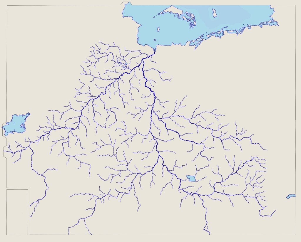
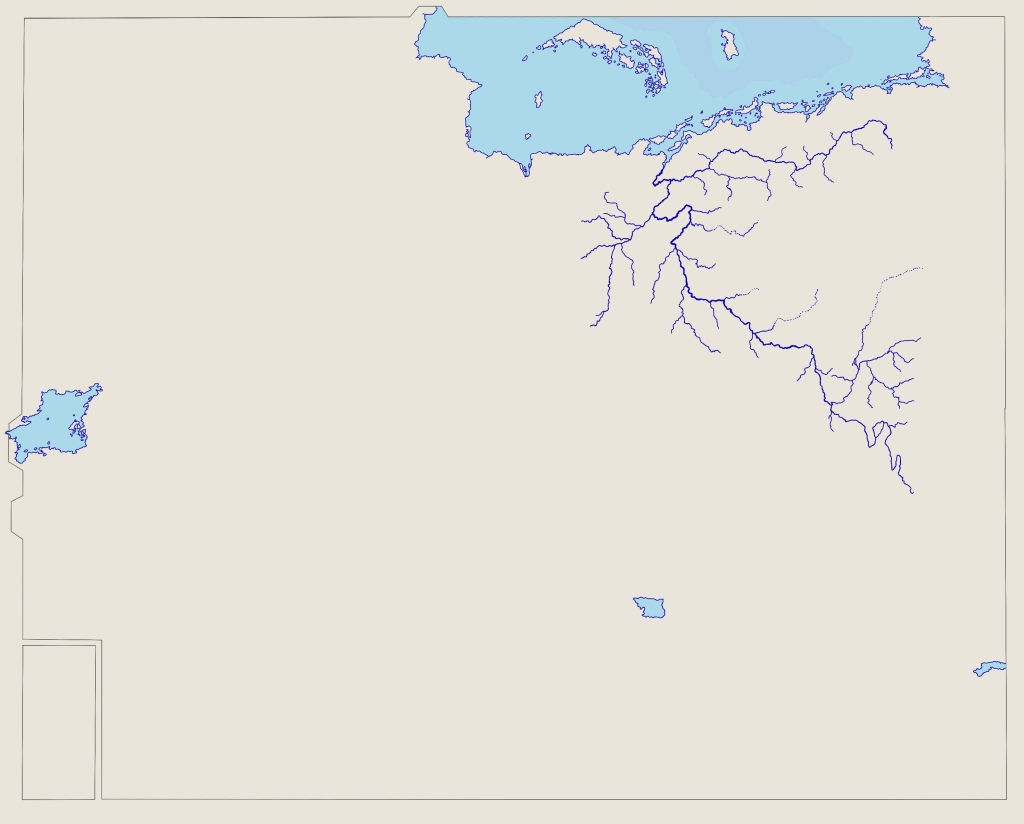
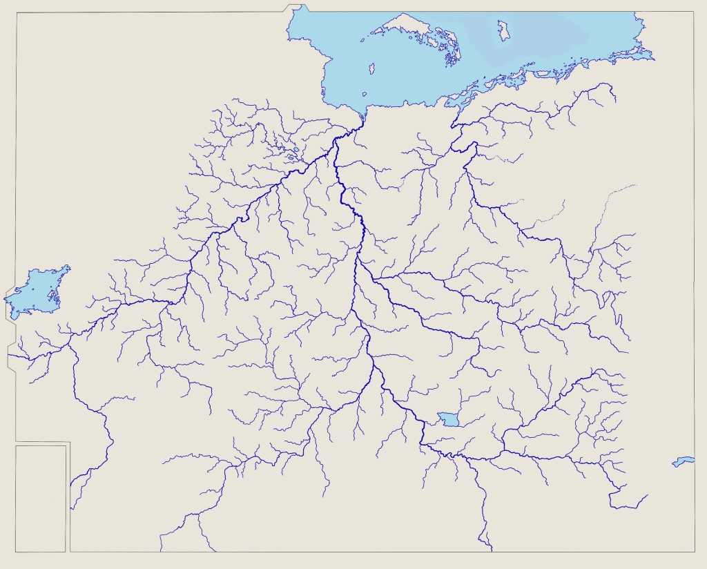
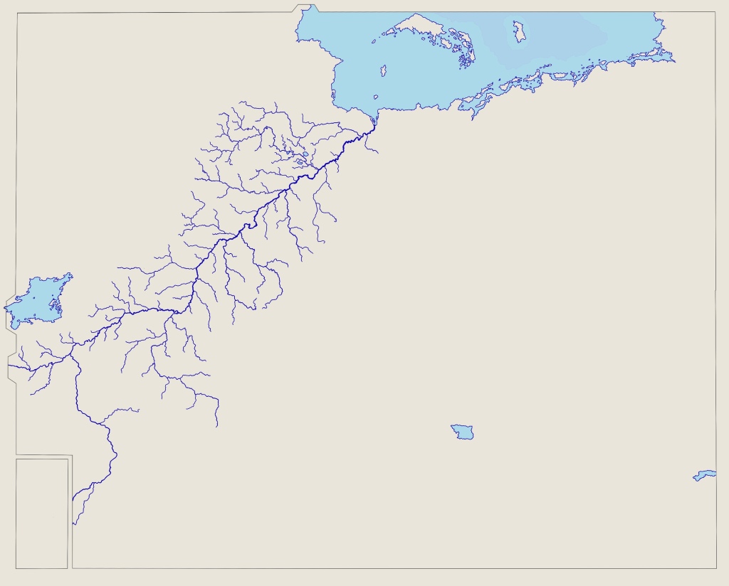
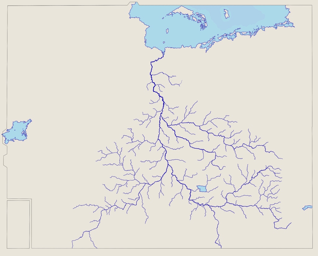
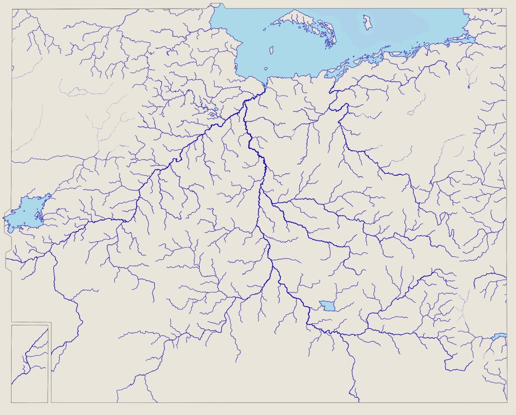
OK, here are a few bits of eye-candy that are helping me think about river transport. I traced them from zomp's 'huge' map of Eretald, more as a form of meditation than anything else.

I got as far as coastlines and rivers. It occurred to me that these resemble maps of river basins from various Earthly reference materials (including Wikipedia).

Here they are: firstly, the whole river system:

Image

Now, the shared Eärdur-Svetla basin:

Image

The Serea basin:

Image

In case anyone would ever want it, the three main river systems of Eretald (Eärdur-Svetla and Serea):

Image

And finally, just the Eärdur, and just the Svetla basins:

Image

Image

Sadly I forgot to add a scale to any of the images. I will probably go back and do so, but I’m away from my iPad at present. The scale on the ‘huge’ map could be used as reference. Very roughly, Lake Como (the most central lake of the three in the lower half of the maps, in the Svetla basin) is approximately 30km by 50km at its widest points. (Incidentally, that makes it about the size of Lake Peipus in Estonia, Europe’s fifth largest lake; you certainly wouldn’t be able to see the opposite shore most of the way around.)
Post Reply