Page 1 of 1
How's my climate map?
Posted: Mon Oct 12, 2020 9:53 am
by LingEarth
This is my first post, so hi, I was on the old board for a little while years ago, as Earthling; don't know if anyone remembers me.
I'm trying to work out climates for my conworld, Rodal, based on Geoff's Climate Cookbook and other websites. Here's my attempt so far:
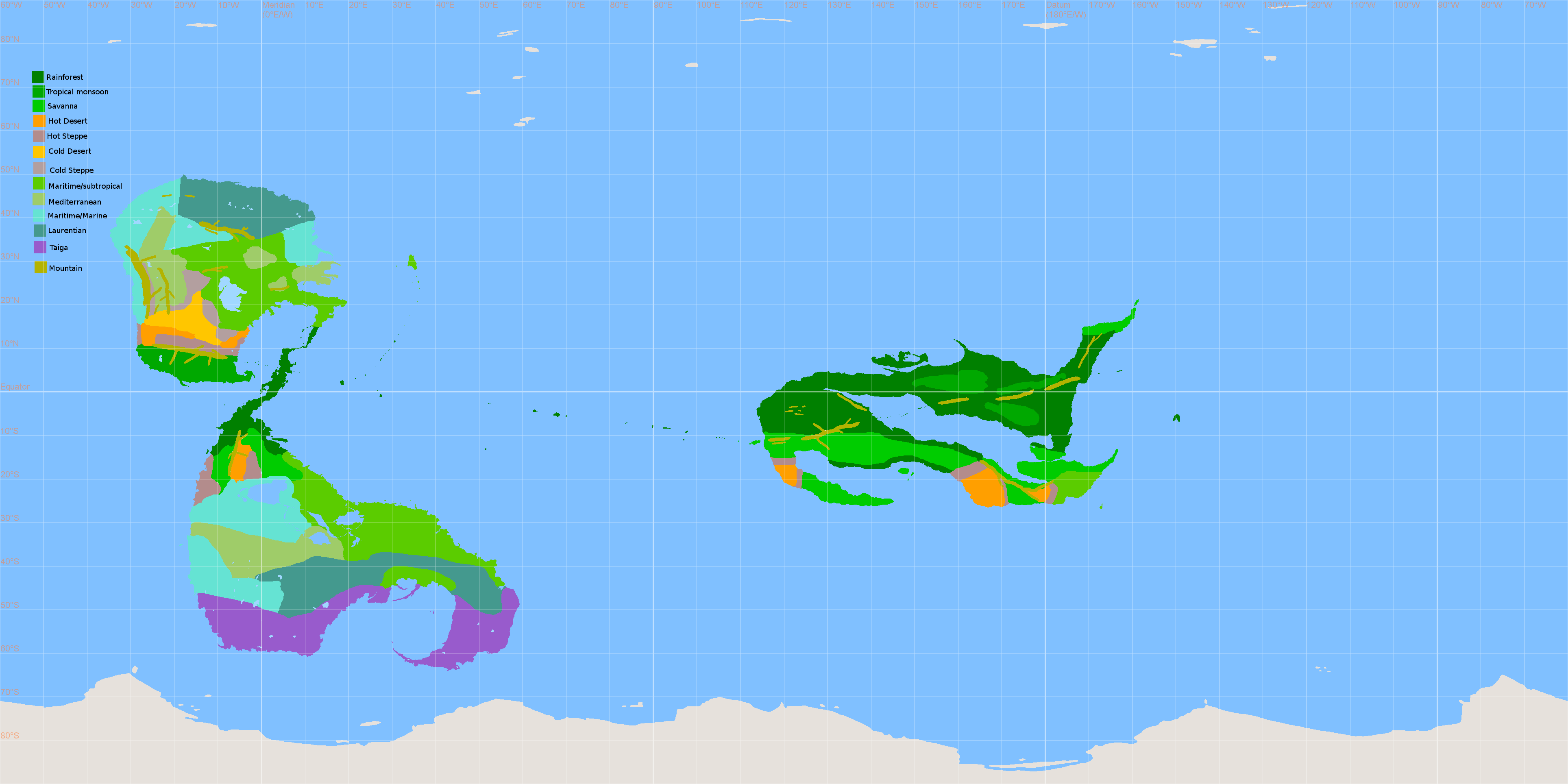
- rodal_v2_climate.png (125.07 KiB) Viewed 8889 times
Here's the maps for pressure, wind, and precipitation that this is based on:
January and
July.
There's some areas that I'm reeeally unsure about, so I'd appreciate any feedback. Also, I didn't mark any climates on the south polar continent; I figure it will be mostly ice cap, but I'm hoping parts of the peninsulas will be somewhat habitable tundra?
Re: How's my climate map?
Posted: Mon Oct 12, 2020 6:07 pm
by Ares Land
Oh, hi!
OK, I'm not terribly good at climate but a few things strike me as weird:
Mediterranean climates are a little too far south: typically these range from 45° to 30° (from Southern France to Cairo, or from Oregon to Sonora). It also tends to border ocean, so parts of that Maritime climate on the west coast should be Mediterranean.
You get a Mediterranean climate east of your mountain; but that's really in the rainshadow; you should get desert or steppe there (there's still quite a bit of precipitation in Mediterranean areas; mountains will block these). Think of the North American Prairies, or Argentinan pampas.
There's probably a bit more desert; typically desert will extend eastwards from West coasts, from about 15° to 30°. You can have desert right next to the ocean.
Of course all of this looks awfully wet! So presumably you have on the whole less dry areas than on Earth. I guess. The Americas might be a good model here.
Re: How's my climate map?
Posted: Tue Oct 13, 2020 3:54 am
by alice
LingEarth wrote: ↑Mon Oct 12, 2020 9:53 ambased on Geoff's Climate Cookbook and other websites.
(runs away in terror)
My first obervation is that there's a lot of water and not much land, which suggests that there won't be as much year-round variation in any given climate as on Earth.
Re: How's my climate map?
Posted: Tue Oct 13, 2020 7:27 am
by Moose-tache
As noted, most of the Light Bulb continent (especially the desters, Mediterranean, and marine environments) needs to be shifted north. The lack of oceanic high pressure zones probably would make some mediterranean climates wetter, but not by this much. Similarly, the large marine blob on the southern continent between 20 and 30 needs to be a lot drier. The equatorial continent is mostly fine.
Re: How's my climate map?
Posted: Tue Oct 13, 2020 8:04 am
by LingEarth
Ares Land wrote: ↑Mon Oct 12, 2020 6:07 pm
Oh, hi!
OK, I'm not terribly good at climate but a few things strike me as weird:
Mediterranean climates are a little too far south: typically these range from 45° to 30° (from Southern France to Cairo, or from Oregon to Sonora). It also tends to border ocean, so parts of that Maritime climate on the west coast should be Mediterranean.
Yeah... I kinda threw Mediterranean climate in a few areas where nothing else quite seemed to fit. I guess the patches of Mediterranean on the east coast of the northern continent should actually be subtropical or marine, like the areas around them?
You get a Mediterranean climate east of your mountain; but that's really in the rainshadow; you should get desert or steppe there (there's still quite a bit of precipitation in Mediterranean areas; mountains will block these). Think of the North American Prairies, or Argentinan pampas.
And actually, the area between the two mountain ranges is supposed to be a high plateau, so it should probably have a climate more like Tibet, though I'm not sure if being so close to the west coast would change that?
Moose-tache wrote: ↑Tue Oct 13, 2020 7:27 am
As noted, most of the Light Bulb continent (especially the desters, Mediterranean, and marine environments) needs to be shifted north. The lack of oceanic high pressure zones probably would make some mediterranean climates wetter, but not by this much. Similarly, the large marine blob on the southern continent between 20 and 30 needs to be a lot drier. The equatorial continent is mostly fine.
By "Light Bulb continent" I assume you mean the northern one? I'm not sure I see the resemblance to a lightbulb but okay.

As for the southern continent, I kinda thought the inland seas there would create more precipitation around them but I suppose not necessarily so far to their west.
Thank you all; I'll work on this some more and come back here.
Re: How's my climate map?
Posted: Wed Oct 14, 2020 4:41 am
by Ares Land
LingEarth wrote: ↑Tue Oct 13, 2020 8:04 am
Yeah... I kinda threw Mediterranean climate in a few areas where nothing else quite seemed to fit. I guess the patches of Mediterranean on the east coast of the northern continent should actually be subtropical or marine, like the areas around them?
You'd get a continental or subtropical climate, I believe. You wouldn't get a marine climate; those are restricted to the east coast. Basically, marine doesn't extend beyond a mountain range; it can extend quite a bit on a plain. On climate maps of Europe, they place the limit between marine and continental around the Polish border, but it's really a continuum. The difference between the French atlantic coast and eastern France, about 1000 km apart, is already quite noticeable.
And actually, the area between the two mountain ranges is supposed to be a high plateau, so it should probably have a climate more like Tibet, though I'm not sure if being so close to the west coast would change that?
Yes, I think so. The climate would be wetter and colder than surrounding areas, though still quite arid below 30°. The Mexican altiplano would be a good model, as well as the Moroccan highlands and southern Iran.
Re: How's my climate map?
Posted: Wed Oct 14, 2020 9:03 am
by Raphael
Ares Land wrote: ↑Wed Oct 14, 2020 4:41 amYou wouldn't get a marine climate; those are restricted to the east coast. Basically, marine doesn't extend beyond a mountain range; it can extend quite a bit on a plain. On climate maps of Europe, they place the limit between marine and continental around the Polish border, but it's really a continuum.
Huh? Europe is at the Western end of the Eurasian landmass.
Re: How's my climate map?
Posted: Wed Oct 14, 2020 9:48 am
by Pabappa
Im pretty sure he meant to say west. Its a simple mistake.
Given how much I love climate, and how much I love maps, I feel like I should be able to say more when I see people making these sort of maps, but my preference has always been for freestyle climate design, .... anything can work if your explanation is self-consistent. Axial tilt, eccentricity, wind speed, etc can all be played with in order to get the climates you want. And with only three continents, each quite different from the others, I'd say it'd be hard to go wrong unless you specifically tried to.
I'd say your map is probably fine the way it is. However, if you did want to get into details, it'd help if you explained the two imgur maps better. You say it's a map of wind, pressure, and precipitation, but I don't know what I'm looking at, exactly. Are the red spirals meant to indicate mountains? Where is the precipitation? But you might not even really need those imgur maps.
Re: How's my climate map?
Posted: Wed Oct 14, 2020 4:52 pm
by LingEarth
Ares Land wrote: ↑Wed Oct 14, 2020 4:41 am
And actually, the area between the two mountain ranges is supposed to be a high plateau, so it should probably have a climate more like Tibet, though I'm not sure if being so close to the west coast would change that?
Yes, I think so. The climate would be wetter and colder than surrounding areas, though still quite arid below 30°. The Mexican altiplano would be a good model, as well as the Moroccan highlands and southern Iran.
Uh, just to clarify, do you mean "yes, being close to the west coast changes that"?
Pabappa wrote: ↑Wed Oct 14, 2020 9:48 amI'd say your map is probably fine the way it is. However, if you did want to get into details, it'd help if you explained the two imgur maps better. You say it's a map of wind, pressure, and precipitation, but I don't know what I'm looking at, exactly. Are the red spirals meant to indicate mountains? Where is the precipitation? But you might not even really need those imgur maps.
Oh, the dark red airbrush areas are high precipitation, and the light brown ones are low precipitation. I just generally sprayed those colors around an area rather than trying to get every little spot. The major mountain ranges are shown as shaded relief on that map, and in yellow on the climate map. Wind is the pink arrows and pressure is the green and yellow circles and lines (green with the letter H for high). I guess those links in the first post actually go to a page where the image is scaled down--I'll change them to go directly to the images themselves so they're full-sized.
Re: How's my climate map?
Posted: Wed Oct 14, 2020 5:04 pm
by Ares Land
Raphael wrote: ↑Wed Oct 14, 2020 9:03 am
Ares Land wrote: ↑Wed Oct 14, 2020 4:41 amYou wouldn't get a marine climate; those are restricted to the east coast. Basically, marine doesn't extend beyond a mountain range; it can extend quite a bit on a plain. On climate maps of Europe, they place the limit between marine and continental around the Polish border, but it's really a continuum.
Huh? Europe is at the Western end of the Eurasian landmass.
Ah, yes, I meant
West, not East. Sorry about that.
LingEarth wrote: ↑Wed Oct 14, 2020 4:52 pm
Uh, just to clarify, do you mean "yes, being close to the west coast changes that"?
Yes, that's what I meant

Re: How's my climate map?
Posted: Fri Oct 14, 2022 3:39 pm
by LingEarth
Well, exactly two years later, I've finally gotten around to making some adjustments:
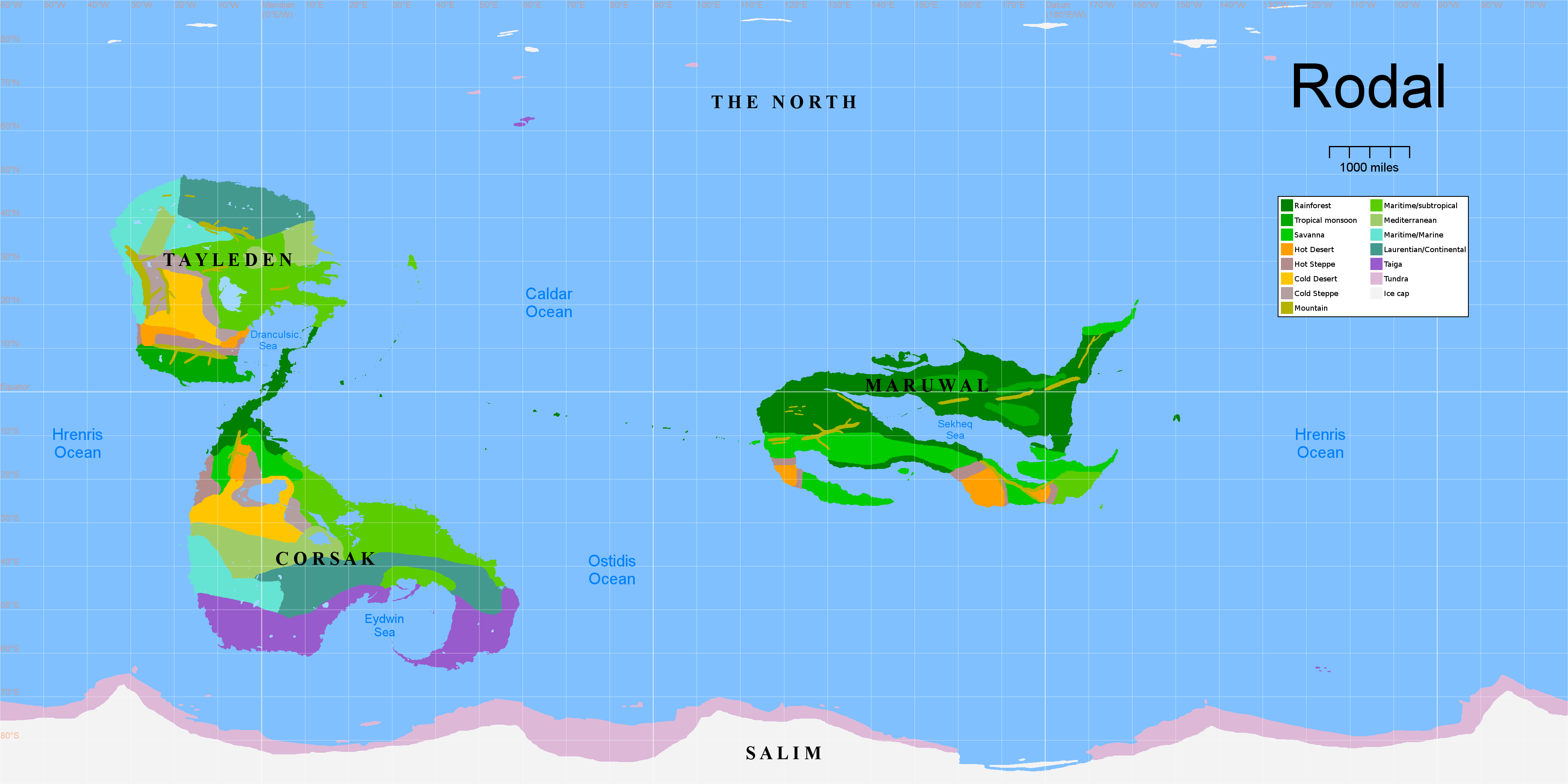
- rodal_v2_climate2.png (192.04 KiB) Viewed 3837 times
(You can right-click on it to see it full-size. I also cleaned up the legend and labeled the continents and oceans.)
I probably won't put much effort into getting every little detail exactly right, but if anyone sees anything that still looks significantly out of place, I'd appreciate it being pointed out.
One particular area I was concerned about is the plateau between the two mountain ranges on the west coast of Tayleden. If it ends up with something like a steppe climate, does it still work to have a major river starting there? Because right now I have a major river starting there.

I'm also unsure what should go on around the various inland seas.
Re: How's my climate map?
Posted: Wed Nov 02, 2022 11:46 am
by Torco
just at a glance, I'd expect that -given that this planet have similar general wind patterns as earch, and that's a big if- the southern coast of the Sekheq sea would be rather drier than its northern coast, cause the dominant wind would be, i guess, going from land to sea <as opposed to where you have wind going from sea to land, which generally leads to a lot of rain>. that being said, that whole sea is pretty near the equator, and it's inland too, so it would get pretty warm and, thus, cause rain all around it. I'd also expect the inland regions of Tayleden to be rather drier <though, well, the color scheme is not the most visible to me, a bearer of eyes red-insensitive>.
overall, i think it's overall plausible.
Re: How's my climate map?
Posted: Fri Nov 04, 2022 4:54 am
by zompist
Some overall reactions. I'm out of practice on this, so don't take it as gospel.
* I think you have monsoon areas in the interior? I'd expect them on the coast.
* I'd expect the western coast of Maruwal to be a bit drier.
* The mountains on Maruwal are weird, like you wanted them to cross the ocean. I'd expect them to curve along the spine of the continent.
* You have cold deserts and steppes starting awfully close to the equator, at about 12 degrees N and 20 S. As a rule of thumb, I'd put them above 30 degrees.
* Similarly, I wouldn't put Marine below 20 degrees unless you're changing the overall atmospheric cells.
* How do you get a chunk of Mediterranean climate in northern Tayleden, and then more Marine to the east?
Re: How's my climate map?
Posted: Sun Nov 06, 2022 2:56 am
by Zju
You probably already know of this, but Artifexian has some nice tutorials on climate.