Telpahké: the thread - Verbal Morphology
Posted: Mon Sep 03, 2018 10:34 am
Contents
Introduction
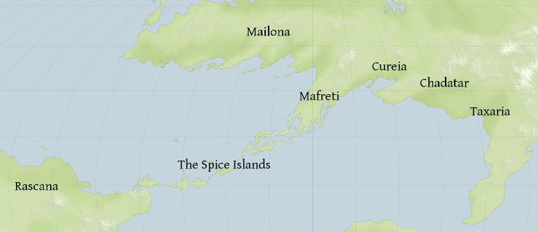
Telpahké is the language spoken by the inhabitants of the chain of islands linking the northern continent of Adeia to the southern continent of Rascana. Known to the inhabitants of Adeia as 'the Spice Islands' (Ṭafolin Atsāf in Qôni, or hā Gairoa Atzātīs in Tailancan), a native name for the archipelago is lacking; the closest equivalent being simply tetelká 'the islands' or Impɔrɛ́ Tetelká 'the islands of the people'.
Closely related to the Tarì languages of Rascana, Telpahké is notable for its unique morphosyntactic alignment (the 'Atzatic alignment'), which corresponds in a number of respects with the Terrestrial Austronesian alignment.
Nomenclature
Whilst the speakers of Telpahké have never been politically united, they possess a strong sense of themselves as an ethnic group. Their autonym is Impár which, while unanalysable in modern Telpahké, is likely cognate to the Tarì śambha 'lineage'. An ancestral form of this name is to be found in the anonymous Tailancan work 'the Periplus of the Southern Ocean', in which the natives of the Spice Islands are referred to as Zambrai. Impár, in Telpahké thought, contrasts with both fɛ́łt 'foreigners' and sokór 'aborigines'.
The name of the language itself is in origin a compound of tíǝl, an archaic form of telká 'island' and pahké, the nominalisation of pahk- 'to speak', thus meaning 'island speech'. It is thought that this name arose initially in contrast to harpahké 'sea speech', the complex avoidance register used while at sea.
Geography and Climate
The Spice Islands lie mainly north of the equator, between 1° south and 16° north. East-west, they stretch approximately 5000 km (for reference, that's roughly the distance from the west coast of Aceh to the border between Indonesia and Papua New Guinea).
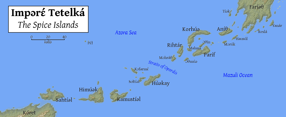
Note to the map: landmasses are named in Telpahké, thus we have Faríǝθ for 'Adeia' and Kóret for 'Rascana'. Interestingly, the Telpahké name for Adeia derives from Phareitus, the southernmost Achaunese city-state, which was a major regional player between the fifth to eighth centuries. The above-mentioned 'Periplus of the Southern Ocean', written some time in the late ninth century, lists the major islands of Korhúa, Paríf, Aniθ and Rihtár as Corsoua, Barīpha, Zanītus and Roudāra. In contrast, seas are given in the Tailancan-derived form usual in Telmonan studies. The native name for the Mazuli Ocean is Tulhɛ́ Harmúǝ 'Ocean of Storms', due to the frequent tropical cyclones arising there; the Azora Sea is by contrast Ɔlpaθɛ́ Harmúǝ 'Peaceful Ocean'.
The scale is denoted in kollíǝ, a native unit of measurement equivalent to approximately 25 kilometres, being judged as the distance a healthy young man might comfortably cover in a canoe on the open sea in a day.
The islands can roughly be divided into two halves at the Straits of Opordis, based on their geological origin and their prevailing climate. The windward islands to the north-east are a southern continuation of the Athros Mountains which divide the continent of Adeia in two. They are geologically old, and their terrain tends to be more forgiving than the leeward islands. Like the Athros Mountains, they are rich in minerals. They have a monsoon climate, with a pronounced wet season during the summer months. Soils are fertile and the prehistoric biome was primarily tropical moist forest.
The leeward islands are mainly volcanic in origin, arising from the subduction of the Rascanan plate underneath the Adeian plate. They tend to be higher in elevation and have a rather less hospitable landscape. They have a tropical rainforest climate, with heavy rainfall all year round. The interiors of the leeward islands are still heavily forested, and settlements are generally only found along the coast. In prehistoric times, the leeward islands were a major source of obsidian, particularly the island of Himúǝk. Himúǝk obsidian has been found as far away as the Ildaia Valley in Mailona.
The geography and climate of the two groups of islands has had a profound impact on their histories and societies. For example, the main crop of the leeward islands is sirés 'taro', grown in the narrow, swampy coastal plains, while that of the windward islands is sómar 'rice', which is intensively grown in terraced paddy fields. Although the leeward islands were the first to be settled, the windward islands have always been able to support a much higher population density: coupled with the geographical proximity to the advanced cultures of Adeia and their commanding position on international trade routes, the windward islands (particularly Aníθ, Korhúǝ and Paríf) have historically been the main locus of Telpahké-speaking civilisation.
Mention must be made of the commodity that has given the islands their most common exonym: spices. The vast bulk of the spices used across Adeia and Rascana are either endemic to the islands or grow particularly well there. Malabathrum, green and black cardamom, cinnamon, long pepper, black pepper, cubebs, cloves, galangal, nutmeg, black cumin, turmeric, ginger, anise and pandan are all commonly cultivated in the islands and form a substantial proportion of their exports.
Next up: a whistlestop tour of the history of the Spice Islands, and a brief outline of society and culture.
- Introduction: what is Telpahké and where is it spoken?
- History 1: Prolegomenon, Prehistory and Red Wings of Death -5000-253
- History 2: Empires and "Heroes" - 253-900
- History 3: Decline of Kings and the rise of the Whore- 900-1300
- Grammar 1: Phonological sketch
- Grammar 2: Palhá harán, the Telpahké script
- Grammar 3: Nominal morphology
- Grammar 4: First- and second-person pronouns
- Culture 1: Imparin clothing
- Grammar 5: The verbal system (introduction)
- Grammar 6: The verbal system (topic and comment, part 1)
- Grammar 7: The verbal system (quick excursus on transitivity and voice assignment)
- Grammar 8: The verbal system (topic and comment, part 2)
- Grammar 9: The verbal system (verbal morphology)
Introduction
Telpahké is the language spoken by the inhabitants of the chain of islands linking the northern continent of Adeia to the southern continent of Rascana. Known to the inhabitants of Adeia as 'the Spice Islands' (Ṭafolin Atsāf in Qôni, or hā Gairoa Atzātīs in Tailancan), a native name for the archipelago is lacking; the closest equivalent being simply tetelká 'the islands' or Impɔrɛ́ Tetelká 'the islands of the people'.
Closely related to the Tarì languages of Rascana, Telpahké is notable for its unique morphosyntactic alignment (the 'Atzatic alignment'), which corresponds in a number of respects with the Terrestrial Austronesian alignment.
Nomenclature
Whilst the speakers of Telpahké have never been politically united, they possess a strong sense of themselves as an ethnic group. Their autonym is Impár which, while unanalysable in modern Telpahké, is likely cognate to the Tarì śambha 'lineage'. An ancestral form of this name is to be found in the anonymous Tailancan work 'the Periplus of the Southern Ocean', in which the natives of the Spice Islands are referred to as Zambrai. Impár, in Telpahké thought, contrasts with both fɛ́łt 'foreigners' and sokór 'aborigines'.
The name of the language itself is in origin a compound of tíǝl, an archaic form of telká 'island' and pahké, the nominalisation of pahk- 'to speak', thus meaning 'island speech'. It is thought that this name arose initially in contrast to harpahké 'sea speech', the complex avoidance register used while at sea.
Geography and Climate
The Spice Islands lie mainly north of the equator, between 1° south and 16° north. East-west, they stretch approximately 5000 km (for reference, that's roughly the distance from the west coast of Aceh to the border between Indonesia and Papua New Guinea).

Note to the map: landmasses are named in Telpahké, thus we have Faríǝθ for 'Adeia' and Kóret for 'Rascana'. Interestingly, the Telpahké name for Adeia derives from Phareitus, the southernmost Achaunese city-state, which was a major regional player between the fifth to eighth centuries. The above-mentioned 'Periplus of the Southern Ocean', written some time in the late ninth century, lists the major islands of Korhúa, Paríf, Aniθ and Rihtár as Corsoua, Barīpha, Zanītus and Roudāra. In contrast, seas are given in the Tailancan-derived form usual in Telmonan studies. The native name for the Mazuli Ocean is Tulhɛ́ Harmúǝ 'Ocean of Storms', due to the frequent tropical cyclones arising there; the Azora Sea is by contrast Ɔlpaθɛ́ Harmúǝ 'Peaceful Ocean'.
The scale is denoted in kollíǝ, a native unit of measurement equivalent to approximately 25 kilometres, being judged as the distance a healthy young man might comfortably cover in a canoe on the open sea in a day.
The islands can roughly be divided into two halves at the Straits of Opordis, based on their geological origin and their prevailing climate. The windward islands to the north-east are a southern continuation of the Athros Mountains which divide the continent of Adeia in two. They are geologically old, and their terrain tends to be more forgiving than the leeward islands. Like the Athros Mountains, they are rich in minerals. They have a monsoon climate, with a pronounced wet season during the summer months. Soils are fertile and the prehistoric biome was primarily tropical moist forest.
The leeward islands are mainly volcanic in origin, arising from the subduction of the Rascanan plate underneath the Adeian plate. They tend to be higher in elevation and have a rather less hospitable landscape. They have a tropical rainforest climate, with heavy rainfall all year round. The interiors of the leeward islands are still heavily forested, and settlements are generally only found along the coast. In prehistoric times, the leeward islands were a major source of obsidian, particularly the island of Himúǝk. Himúǝk obsidian has been found as far away as the Ildaia Valley in Mailona.
The geography and climate of the two groups of islands has had a profound impact on their histories and societies. For example, the main crop of the leeward islands is sirés 'taro', grown in the narrow, swampy coastal plains, while that of the windward islands is sómar 'rice', which is intensively grown in terraced paddy fields. Although the leeward islands were the first to be settled, the windward islands have always been able to support a much higher population density: coupled with the geographical proximity to the advanced cultures of Adeia and their commanding position on international trade routes, the windward islands (particularly Aníθ, Korhúǝ and Paríf) have historically been the main locus of Telpahké-speaking civilisation.
Mention must be made of the commodity that has given the islands their most common exonym: spices. The vast bulk of the spices used across Adeia and Rascana are either endemic to the islands or grow particularly well there. Malabathrum, green and black cardamom, cinnamon, long pepper, black pepper, cubebs, cloves, galangal, nutmeg, black cumin, turmeric, ginger, anise and pandan are all commonly cultivated in the islands and form a substantial proportion of their exports.
Next up: a whistlestop tour of the history of the Spice Islands, and a brief outline of society and culture.
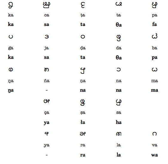

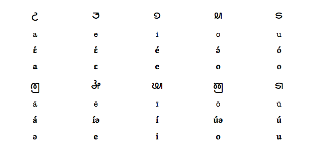


 çe-ṁ-ˈbā-ra. However,
  yi-ṁ-ˈbā-ra or
  ī-ṁ-ˈbā-ra are far from uncommon (indeed the last is probably the most commonly encountered on Paríf and its surrounding islands.