River transport in Eretald

Almea and the Incatena
User avatar
sasasha
Posts: 634
Joined: Mon Aug 06, 2018 11:41 am
Location: Todmorden

Re: River transport in Eretald

Post by sasasha »

I've got so many things to say on this subject for some unknown reason! :P But I can't spend much more time on it right now, I've been fairly obsessed with it all for days and probably need to do some other stuff for a bit. Thank you both so much for all your extremely helpful comments ‒ which, don't worry, I have heard ‒ I'm glad you like the drawings zomp, and I'll come back to this properly in a few days if I can.

I think I want to leave all this (for now) with the following general point.

If you are in the business of trading over rivers, and you have the means, you go to the best possible market for your goods. That's a product of market availability and your ability to get there (including what you might miss out on by going). For some, that might just be the other side of the river. For a number of early medieval trading groups from the east of Sweden, that meant Constantinople ‒ a much more difficult destination than Verdúria is for our 35th century Cereians.

The Varangian trade seems unlikely, but it produced its own infrastructure. We don't know exactly much of what that infrastucture consisted of then (ships, portages, food supply networks, agents, etc etc), but we sure know what it turned into: several modern nations ‒ including the largest on Earth.* That's a bit more of a complex and impressive legacy than a potential development in the history of scheduling.

The point is, people do things to travel long distances for trade that don't necessarily seem rational, because they believe they can probably make good out of it. And often, where there's a will, there's a way ‒ and they make it easier for themselves or someone else to do it next time. This process frequently drives social and cultural development.

I get the feeling that we're reducing this discussion a bit much to describing ‘what is normal’. That's part of what I want to use this thread to help define; but there's also the marginal, the unexpected, the surprising things people will do when they're desperate or frustrated or filled with a dream or conviction (which may or may not be founded).

As someone who likes stories I often gravitate to the latter ‒ the marginal ‒ and that's not to say I don't also have an appreciation for establishing ‘what is normal’. But people's behaviour will always seep through those bounds and establish things that previously seemed unlikely.

I want to be clear I'm not making any argument for ‘my boat’ and the operational model I've suggested! I hear the Word of God :D I got the scale way off wrt the number of people who'd fit on a vessel like this (as zomp suggested the other day, I wasn't visualising it right). Ditto, I think, the number and regularity of journeys in this period. But I must say a lot of this is based on a bit of a miscommunication: I absolutely never saw the ‘schedule’ as I created it to be ‘binding’. It's just that the river has a speed, and if a few passengers are going to hop on, then they're going to want a rough idea of how long it's going to take them to get somewhere. The schedule itself began as a diagram for me to try to work out how long it might take to get from place to place, and I'm not seriously suggesting it would be used as a commercial document (‒ for a start, who would print it, why and where?). If it were, as zomp said, it would be purely aspirational. The word schedule gives the wrong impression of what I was doing creating and presenting it ‒ I am trying to establish how river travel works in Eretald, not trying to schedule it! :)

Once again, thanks for the discussion, as I think we're all closer to understanding this deeply!


(*Trying to find ways to put this point sensitively today is difficult; I apologise if I have failed to do so!)
Glenn
Posts: 126
Joined: Wed Feb 15, 2023 6:40 am

Re: River transport in Eretald

Post by Glenn »

Raphael wrote:Now I wonder, when and why did the robbers along major roads that were so notorious about 300-200 years ago disappear?
A glance at Wikipedia, et al offers some possible explanations:

- Increased policing of the roads by state agencies.

- The expansion of manned toll roads with restricted access.

- Increased access to firearms by ordinary citizens (in other words, the robbers may be armed, but coach drivers and passengers might also be armed, and better able to fight back).

- Increased population density (translating to fewer lonely roads and more witnesses)

- Greater use of paper banknotes as opposed to coins, with the former being easier to trace.

One theory that surprised me is related to the enclosure movement in English, especially the Inclosure Act of 1773, which led to more landowners closing off formerly common land with stone walls to serve as grazing land for sheep; it’s harder to spring out of hiding and ambush somebody if you have to climb a stone wall in the process. In addition, the overall political and economic situation may play a role (highway robberies may be greater in times of instability, unrest, and civil war, or in the wake of war, as former soldiers turn to other armed occupations).

I have been following this thread with interest; Kiarlon, the con-country that I have been poking (mostly unsuccessfully) at for many years, also occupies the basins of two large rivers, and I imagine riverboats as playing a major role in travel and economic activity there as well (as well as having The River, and possibly the contrast between The River and The Land, possibly play a large role as a metaphor in philosophy and religion.)
User avatar
Raphael
Posts: 6958
Joined: Sun Jul 22, 2018 6:36 am

Re: River transport in Eretald

Post by Raphael »

Thank you, very informative!
User avatar
sasasha
Posts: 634
Joined: Mon Aug 06, 2018 11:41 am
Location: Todmorden

Re: River transport in Eretald

Post by sasasha »

A quick question for zompist: the Eärdur is said to be 3km wide at Pelym and needs to be crossed by ferry. Only 20km upriver, at Anaseri, there is a bridge (by 3480).

I'm curious about this bridge ‒ when does it date from? Does the river narrow a lot here (which surely would make a bridge with arches harder to build, as the river would be deeper)? Can big boats pass underneath?

Some briefly researched models to chew on... The Congo remains narrow towards its mouth ‒ but is more than 600 feet deep in parts. 18th century bridges on the Ganges seem to have peaked at a couple of hundred metres (using quite narrow arches all the way along). Trajan's Bridge is probably a good model? Or the Bridge at Arelate?
zompist
Site Admin
Posts: 4007
Joined: Sun Jul 08, 2018 5:46 am
Location: Right here, probably
Contact:

Re: River transport in Eretald

Post by zompist »

sasasha wrote: Sat Feb 17, 2024 5:29 am A quick question for zompist: the Eärdur is said to be 3km wide at Pelym and needs to be crossed by ferry. Only 20km upriver, at Anaseri, there is a bridge (by 3480).

I'm curious about this bridge ‒ when does it date from? Does the river narrow a lot here (which surely would make a bridge with arches harder to build, as the river would be deeper)? Can big boats pass underneath?
I may have to revisit this, but I imagine the Svetla as pretty wide. The Mississippi has an average width of 2 mi (3 km), so 1 to 3 km seems like a good guess.

The Caďinorians could build as well as the Romans, so I imagine they bridged the river at several points. Some but not all of them would have collapsed in the Dark Years.

The bridge in 3480 Anaseri is likely to be a Verdurian construction.

You could certainly get barges and coroni under the bridges. If you have a really big mast... well, maybe it has to be lowered. I'm not sure how this was done in earthly history...
User avatar
sasasha
Posts: 634
Joined: Mon Aug 06, 2018 11:41 am
Location: Todmorden

Re: River transport in Eretald

Post by sasasha »

zompist wrote: Sat Feb 17, 2024 6:34 am
sasasha wrote: Sat Feb 17, 2024 5:29 am A quick question for zompist: the Eärdur is said to be 3km wide at Pelym and needs to be crossed by ferry. Only 20km upriver, at Anaseri, there is a bridge (by 3480).

I'm curious about this bridge ‒ when does it date from? Does the river narrow a lot here (which surely would make a bridge with arches harder to build, as the river would be deeper)? Can big boats pass underneath?
I may have to revisit this, but I imagine the Svetla as pretty wide. The Mississippi has an average width of 2 mi (3 km), so 1 to 3 km seems like a good guess.

The Caďinorians could build as well as the Romans, so I imagine they bridged the river at several points. Some but not all of them would have collapsed in the Dark Years.

The bridge in 3480 Anaseri is likely to be a Verdurian construction.

You could certainly get barges and coroni under the bridges. If you have a really big mast... well, maybe it has to be lowered. I'm not sure how this was done in earthly history...
Thanks! I've found a 14th century bridge that manages about a kilometer, is still standing, has a very high clearance (because of the topography) and is rather pretty: Pont-Saint-Esprit. And Trajan's Bridge was over a km... so I reckon if the river happens to be about 1km wide at Anaseri, it's reasonable to expect a bridge there. (The river could always widen out again on either side; I think they often narrow a bit at bends.)

I think you could add it to a list of tourist attractions in Eretald, though! It would no doubt be impressive.
User avatar
sasasha
Posts: 634
Joined: Mon Aug 06, 2018 11:41 am
Location: Todmorden

Re: River transport in Eretald

Post by sasasha »

OK, here are a few bits of eye-candy that are helping me think about river transport. I traced them from zomp's 'huge' map of Eretald, more as a form of meditation than anything else.

I got as far as coastlines and rivers. It occurred to me that these resemble maps of river basins from various Earthly reference materials (including Wikipedia).

Here they are: firstly, the whole river system:

Image

Now, the shared Eärdur-Svetla basin:

Image

The Serea basin:

Image

In case anyone would ever want it, the three main river systems of Eretald (Eärdur-Svetla and Serea):

Image

And finally, just the Eärdur, and just the Svetla basins:

Image

Image

Sadly I forgot to add a scale to any of the images. I will probably go back and do so, but I’m away from my iPad at present. The scale on the ‘huge’ map could be used as reference. Very roughly, Lake Como (the most central lake of the three in the lower half of the maps, in the Svetla basin) is approximately 30km by 50km at its widest points. (Incidentally, that makes it about the size of Lake Peipus in Estonia, Europe’s fifth largest lake; you certainly wouldn’t be able to see the opposite shore most of the way around.)
User avatar
sasasha
Posts: 634
Joined: Mon Aug 06, 2018 11:41 am
Location: Todmorden

Re: River transport in Eretald

Post by sasasha »

Necroposting my own thread so I can ask about Svetla bridges. :) (Limited to Svetla downstream of Araunicoros for now, including Anaseris even though it's technically on the Eärdur)

Places I think ancient bridges were:

Araunicoros (seems likely)
Cantiego (attested)
Aenocur (I would guess)
Bogira?
Aerivileon?
Šerian?
Ulian (attested)

NB I think you mentioned that none would survive into the early modern era. (Or maybe there could be an ancient bridge still intact at, e.g. Araunicoros...? But I think unlikely they would remain.)

Not Anaseris, I don't think (I remember you saying the bridge there was a Verdurian construction); lack of bridge doesn't mean it wasn't a common ancient crossing place, of course. And not Ctésifon: for whatever reason it seems from your Ctésifon maps that a bridge never crossed the main span until after 2800. (Seems a bit odd, that, given that the bridge at Cantiego was so ancient! But there are probably geological/hydrological reasons! And perhaps there was an ancient bridge a little way down or upstream from Ctésifos, and perhaps they didn't want invaders to be able to walk onto the island so easily.)

I have theories about the types of bridges and motivations behind all of them. But I won't go into those now. I'm just hoping to ascertain where the bridges were first, and am very much open to help!

Places I think medieval-early modern bridges were/are on the same span:

Aránicer
Zariaspa
Dobray?
Liynnor
Ctésifon (attested)
Vyat (attested)
Ulian (attested)
Šerian?
Beluana?
Anaseri (attested)

It would be great if some of these could be confirmed or denied. And if any more need to be added – great! I think bridges over this kind of river would be really culturally important/iconic. I'd like to whip out my hydrological theories, but I reckon there might be some in place already!

Thank you! :)
zompist
Site Admin
Posts: 4007
Joined: Sun Jul 08, 2018 5:46 am
Location: Right here, probably
Contact:

Re: River transport in Eretald

Post by zompist »

sasasha wrote: Wed Feb 18, 2026 6:09 pm Necroposting my own thread so I can ask about Svetla bridges.
Places I think ancient bridges were:

Araunicoros (seems likely)
Cantiego (attested)
Aenocur (I would guess)
Bogira?
Aerivileon?
Šerian?
Ulian (attested)
Definitely Araunicoros and Aenocur. Maybe only one of Bogira and Aerivileon-- let's say Bogira. Scehiranda, I dunno, maybe. :)
NB I think you mentioned that none would survive into the early modern era. (Or maybe there could be an ancient bridge still intact at, e.g. Araunicoros...? But I think unlikely they would remain.)
Araunicoros was lost to the barbarians, so probably no.
And not Ctésifon: for whatever reason it seems from your Ctésifon maps that a bridge never crossed the main span until after 2800. (Seems a bit odd, that, given that the bridge at Cantiego was so ancient! But there are probably geological/hydrological reasons! And perhaps there was an ancient bridge a little way down or upstream from Ctésifos, and perhaps they didn't want invaders to be able to walk onto the island so easily.)
It does seem odd, but note that most trade was by river anyway, and river crossings by ferry were quite normal. It's not like anyone was isolated from the west bank: the easiest route is to go upriver, then take the Isiza river west, then go north.

It's also conceivable that there was a bridge before the civil war; and afterward, as you suggest, the emperors preferred the security of no bridge.

All the modern cities you mention would have bridges by 3480. It would take more research than I'm willing to do before dinnertime to decide how far back they go. :) Probably not much in the Dark Years at all.
User avatar
sasasha
Posts: 634
Joined: Mon Aug 06, 2018 11:41 am
Location: Todmorden

Re: River transport in Eretald

Post by sasasha »

zompist wrote: Wed Feb 18, 2026 6:36 pm
sasasha wrote: Wed Feb 18, 2026 6:09 pm Necroposting my own thread so I can ask about Svetla bridges.
Places I think ancient bridges were:

Araunicoros (seems likely)
Cantiego (attested)
Aenocur (I would guess)
Bogira?
Aerivileon?
Šerian?
Ulian (attested)
Definitely Araunicoros and Aenocur. Maybe only one of Bogira and Aerivileon-- let's say Bogira. Scehiranda, I dunno, maybe. :)
Ok, cool. I mean... There could have been short-lived bridges in various places, something like the longevity of Trajan's of Constantine's Bridge... But if they're destroyed, dismantled or fail, the resources aren't necessarily going to appear magically to rebuild them. Maybe Scehiranda was one of those...?
And not Ctésifon: for whatever reason it seems from your Ctésifon maps that a bridge never crossed the main span until after 2800. (Seems a bit odd, that, given that the bridge at Cantiego was so ancient! But there are probably geological/hydrological reasons! And perhaps there was an ancient bridge a little way down or upstream from Ctésifos, and perhaps they didn't want invaders to be able to walk onto the island so easily.)
It does seem odd, but note that most trade was by river anyway, and river crossings by ferry were quite normal. It's not like anyone was isolated from the west bank: the easiest route is to go upriver, then take the Isiza river west, then go north.

It's also conceivable that there was a bridge before the civil war; and afterward, as you suggest, the emperors preferred the security of no bridge.
What about an ancient bridge at Dalmaž, instead? As in, the bridge used by Ctésifon (the city) was 25km upstream... The city would be protected from the west by the river, and from the east by Tasurcaln. Any army using the Dalmaž bridge (in either direction) would still have those obstacles to contend with, and a Caďinorian army could easily cross the Dalmaž bridge from Ctésifon in a day’s march. (Or be ferried right across if they needed to reach the west bank of the Svetla quickly.)

Are there Caďinor names for Ulian and Dalmaž, btw?
All the modern cities you mention would have bridges by 3480. It would take more research than I'm willing to do before dinnertime to decide how far back they go. :) Probably not much in the Dark Years at all.
I was avoiding thinking about a stressful meeting at work (fantastic motivation!) and started writing a hydrological assessment of these sites as a distraction. I tried to make guesses from maps and Almeopedia etc about soil type, sediment load, gradient... Things that have a bearing on what types of crossings might work where. There might be some helpful ideas in it if you do decide to decide. It's not ready yet but I'll post it soon in case it is helpful.
User avatar
sasasha
Posts: 634
Joined: Mon Aug 06, 2018 11:41 am
Location: Todmorden

Re: River transport in Eretald

Post by sasasha »

So, this piece of work is probably not going to get finished. It would be a lot to work out. I’m posting it here in its current form. It’s a bit mangled by my ideas shifting as I was writing it. It only considers the river downstream of Ctésifon. It’s 0% canonical at this point, merely a repository of suggestions (Zomp hasn’t seen it, but I don’t want to clog up his inbox any more atm!) with much conjecture on my part, though it was attempting to be rooted in whatever hydrology I could get online. There was an archaeological study of the Mississippi which I now can’t find that was particularly helpful in terms of changes to sedimentation with increased infrastructure upstream. I’ll update this if I find it. Anyway. Perhaps some of this is of interest to worldbuilders working with big rivers.

To summarise the general ideas, not all of which made it into this document yet:

‒ ancient middle and lower Svetla was braided, with particularly wide braided sections forming crossing points I’ve termed ‘wetland nodes’ (NB all of the below only applies to the Svetla downstream of Ctésifon)
‒ high ground near those formed the central places of the age
‒ one of these was anciently bridged, that is, Cantiego, with a pontoon-and-drawbridge structure a bit like the Roman bridge at Arles (but much longer) built in the 800s
‒ increasing Caďin infrastructure such as tributary dams and weirs and irrigation systems in the highlands of Ctésifon led to reduced sedimentation downstream
‒ this cut deeper channels in the middle section of the river and significantly narrowed it in most of its length, though some wetland braided areas remained (especially at Dageda/Anaseris)
‒ Dageda/Anaseris developed as a crossing point with a complex network of fords, causeways and bridges, including one (or some) with drawbridges like at Cantiego
‒ a later type of colossal bridge-making developed in the deepened, narrowed condition of the middle river around the time of Ervëa, which relied on digging a diversion channel to take the water during the driest part of the year, leaving the riverbed mostly dry to build on (this is how Trajan’s bridge was built; a fuller description of this type can be found in my travelogue piece on Ulian). These developed at Ulian, Aenocur, maybe Šerian (and maybe elsewhere?), and probably the new Vyat bridge, built in 2240. There were probably more examples upstream where the river was narrower, for instance, maybe Dalmaž, and points yet further upstream
‒ no ancient colossal bridges north of Ctésifon survived the Dark Years and the technology to build them was lost. (The oldest attested currently standing bridge appears to be the new Vyat bridge, so either it’s an exception or doesn’t count as it’s a bit later.)
‒ a medieval type of colossal bridge developed using huge cofferdams, cutwaters, gothic arches and overflow arches, which didn’t require a diversion channel. Its model is the 2800s bridge at Ctésifon, scaled up; Verduria-city’s Arcaln Bridge (? date unconfirmed) was presumably also of this type, and its replacement Desi Ževuran (3200s) is a classic example. It is essentially the way medieval European bridges were built but about twice as long as any European examples. (This is the one part that is technologically without Earthly analogue ‒ but had the Renaissance been centred around the Danube instead of the Po, I think we could have seen it. The Pont d’Avignon was, to be fair, around 900m, which is probably only a little less than some of these.) The modern bridge at Ulian is in this category, and those at Anaseri, Šerian and both bridges at Dobray. Their clearance is such that coronî can pass beneath (at least, with masts lowered). Some might have had wooden superstructures, to reduce the overall weight.

EDIT: Something I forgot to say ‒ the Meuna-Svetla likely has a high sedimentary load due to glacial flour and arid tributaries running through the Barbarian Plain. This makes its original character in the suddenly flat ‘midlands’ (after leaving the hilly Elcaďin area) likely to be highly braided.


More: show
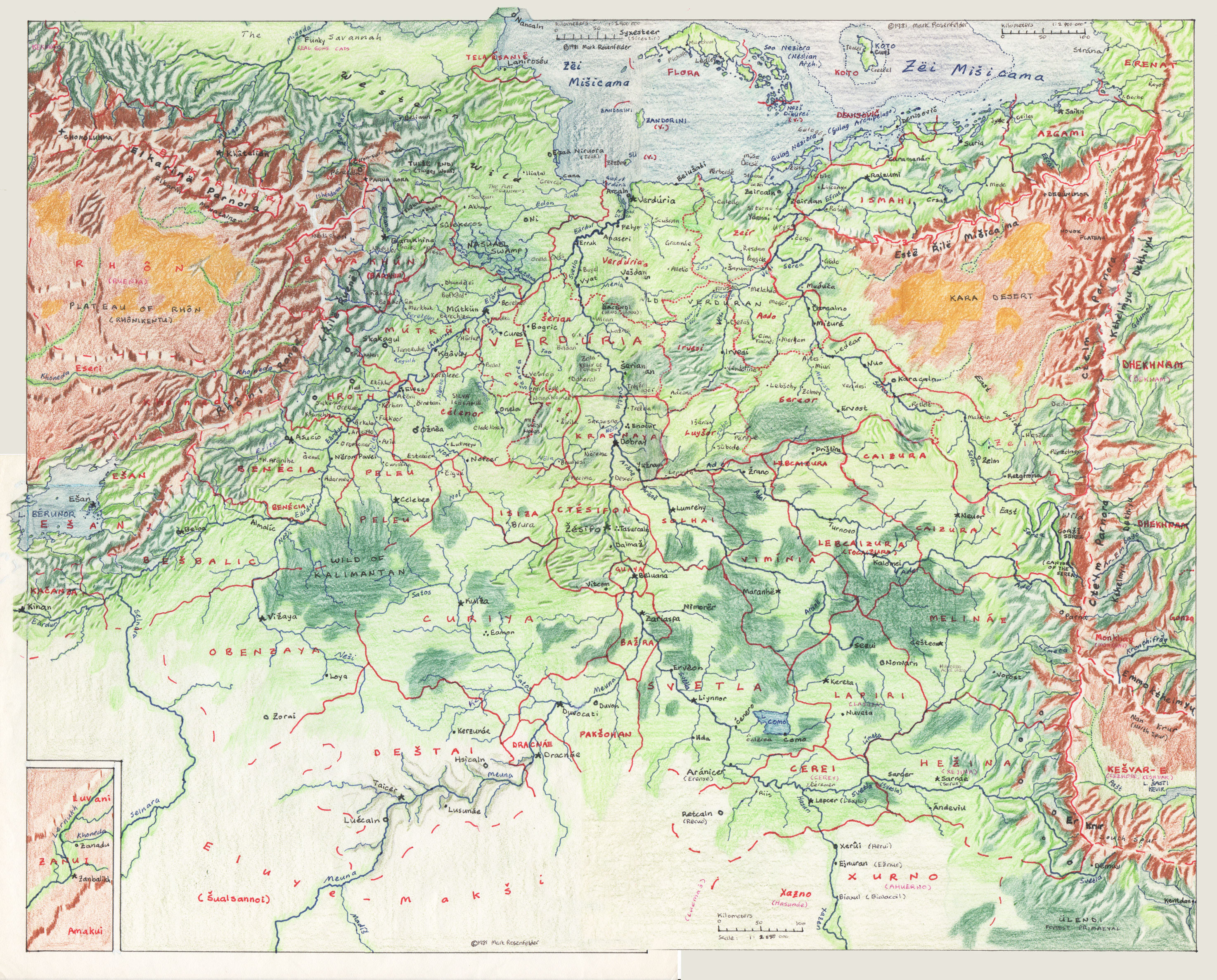
Wetland Nodes and Colossal Bridges: the Urban Pattern of the Mid to Lower Svetla

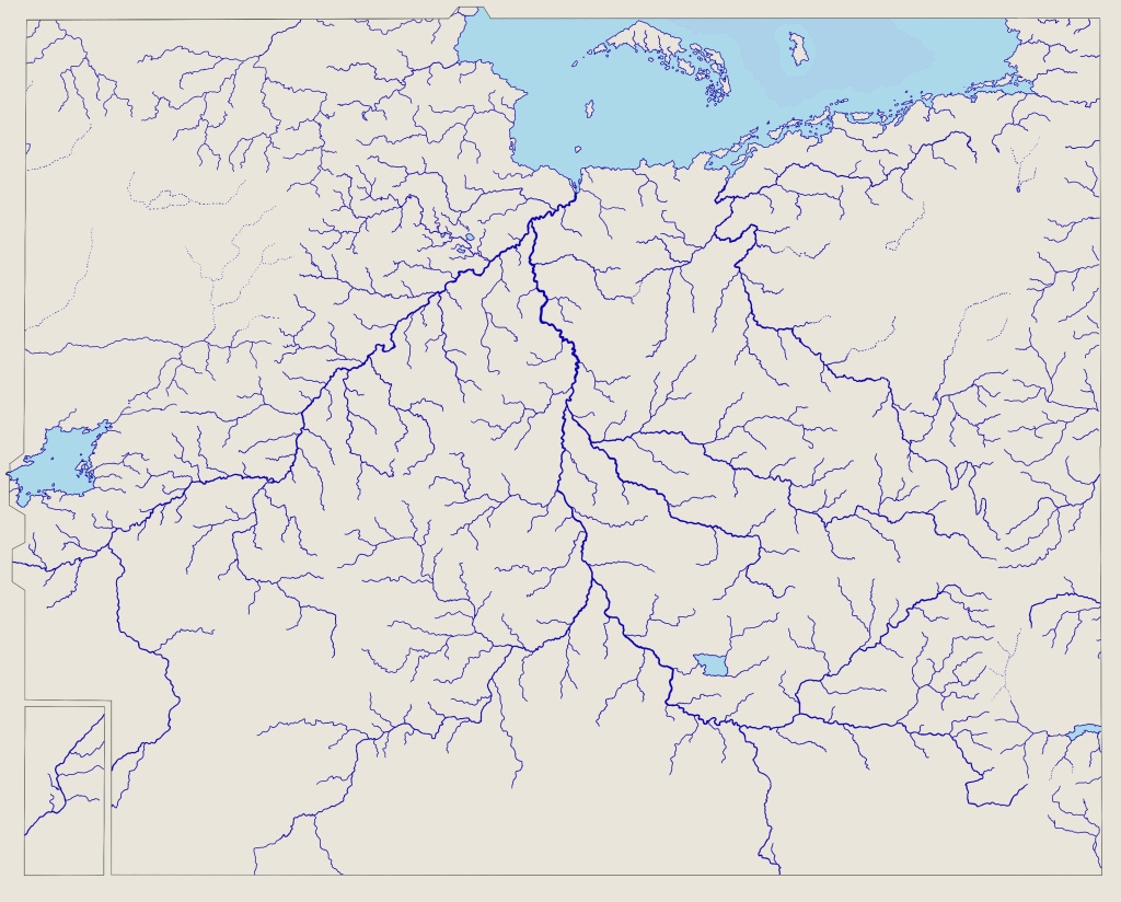
Aenocur, Šerian, Ulian, Cantiego/Vyat, and Anaseri: the five locations on the Svetla north of Dobray where a bridge has ever stood, whether in ancient times or now. In each case, the river today is between one and three cemisî wide. How has this feat of engineering, economy and politics been achieved? And what of their hinterlands, in the midlands between Ctésifon and Arosd ‒ what inspired the wider pattern of settlement which has prevailed in this landscape for millennia?

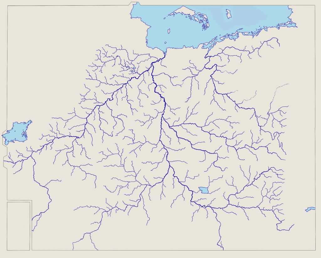
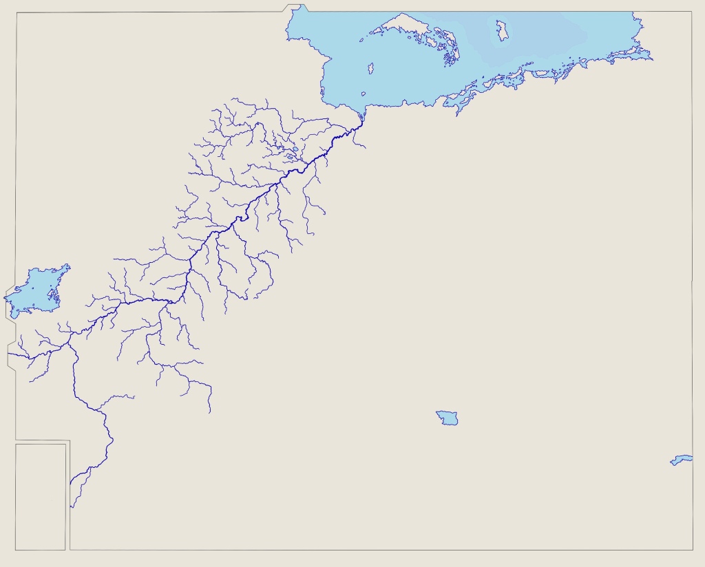
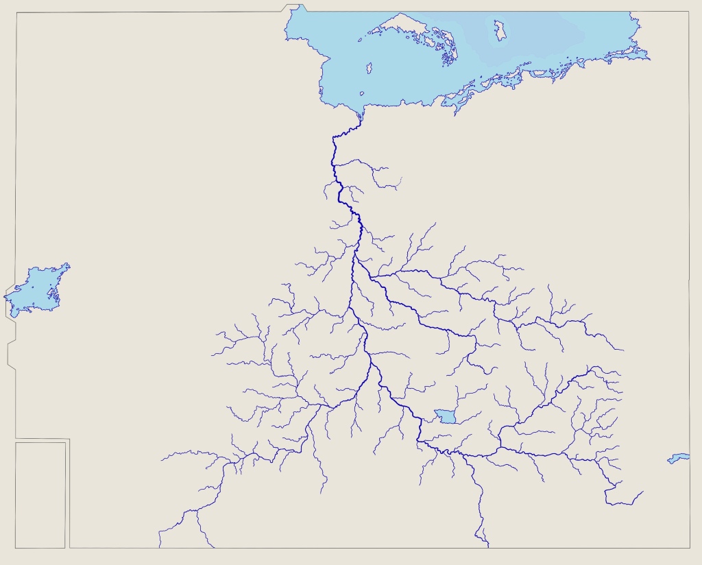
To understand the position of the towns and bridges along the middle and lower Svetla we must first understand something about the river in ancient times. The Svetla, already around a cemisa wide on average, proceeded from the Elcaďin highlands north of Ctésifon into a 100-cemisa-wide valley between the Irvesi and Curesi highlands. In doing so it widened considerably, particularly after Dobray. This was partly the result of a higher volume of water from tributaries, especially the sediment-rich Aränë/Adel, but also due to changing soils and a lessening gradient, which encouraged the banks to spread out greatly. In many places the increased width compensated for the increased flow, meaning that there were numerous sections on this (Šerian) section of the middle Svetla which were both wider and shallower than the Elcaďin section, and where many shifting islands writhed in between the waters.

After Ulian, at the northern boundary of Šerian province, the surrounding terrain morphed from a wide valley with gentle slopes and gradient into a flat plain. Here there was a much greater deposition of alluvial material, creating levees some way inland from the normal course of the river, and even wider yet shallower channels forming complex braided networks of water and land. The Meťaiun etymology of Anaseri coincides with our understanding of its ancient landscape: ‘duck place’, suggesting a wetland environment, not the deep, monolithic river of today. (Though it must be said, the ducks abundantly remain.)

No weirs, kiddles, dams, irrigation channels or bridges reduced the flow of either water or sediment. Without such obstructions withholding sediment (which increases friction, slowing the force of the flow and lessening the erosion of the riverbed), deposition was stronger than today, and erosion weaker. There was also no human intervention at all to control seasonal variations in flow, meaning that various broad sections of open water could reduce to networks of smaller channels during the drier winter – and conversely that flood-plains a dozen cemisî across might form in the wettest summers. The precise course of the river would change from year to year, flood to flood.

Imagine this environment to the early humans. It was unpredictable and hazardous, and yet those places ‒ let us call them ‘wetland nodes’ ‒ where the river yawned outwards into great, shallow, slow-flowing wetlands provided numerous opportunities. Firstly, for nutrition: fish and birds, reptiles and amphibians, game seeking to drink en masse, and a host of edible plants clustered here when the waters allowed. Secondly, the environment directly provided useful materials, such as kena reeds, thought to be used for objects as diverse as blow-darts, paintbrushes, garments, roofs and musical instruments. Thirdly, for movement: shallower, slower channels might be sequentially forded, swum or rafted much more easily, especially in winter. Our species is particularly at home in water, given our genetic ancestry. It would be a laborious, risky crossing, and far from dry ‒ but in certain braided places, these humans might cross the whole span of the river without need for watercraft, allowing access to new hunting grounds, resources, and neighbours.

To agriculturalists, the nodes provided even more valuable opportunities. Cattle, the source of early wealth, could be driven across them in relative safety, and both farmers and armies found it possible to cross to new pastures, markets and rivals, especially on horseback. The landscape inspired irrigation channels and allowed them to be easily cut, while the annual floods boosted the fertile capacity of the land. Archaeology points to a lively exchange of colourful shells originating in such places, and these and gold captured in the wetlands found their way into jewellery and ceremonial objects of the early Meťaiun settlements.

Permanent settlement was impossible at the nodes, for obvious reasons. Instead, hills and high ground close by nodes were the central places of the age; and ridges of higher land likewise provided dry passage between them. Sometimes, the high ground included river islands of rockier, higher ground outcropping from the surrounding plain. As boat-building became more advanced and people developed the capacity to navigate deep, swift, wide waters more reliably, a trinity of favourable circumstance dictated the seats of power along the river: proximity to wetland nodes, defensible/traversable high ground, and natural wharves on the riverbanks where numerous boats could put in at once. We can call these ‘enhanced nodes’. They were hubs of transition between the rhythms of the land and the axis of water.

A list of places scoring well against these criteria, where known, corresponds to many of the town locations we will consider in this paper. Perhaps unsurprisingly, four items from the list we began with ‒ Šerian, Vyat, Aenocur and Anaseri ‒ comprise, to our knowledge, the most quintessential of them on the ancient river north of Ctésifon. Dobray and Ulian count as special cases. We can then consider a second tier of central places: locations that have never hosted a bridge, but meet the criteria to a lesser extent. For instance, Erruk had defensible high ground and natural wharves, and commanded river travel, but did not possess shallow, slow channels, which accounts for the lack of evidence of its importance in the early period.

Another important consideration in the prominence of our five is their hinterlands. The general condition of the land in such early times is difficult to comprehend. Great tracts of forest shadowed the land and precluded movement, especially in upland areas. No hard roads can be proven to predate the Easterners, so the thin parcels of land not shrouded by forest upon which people might live were connected, if at all, by water or mere dirt tracks. Even in forest zones, then, the very floods that frustrated settlement enabled communication, through suppressing tree-growth and creating open meadows alongside the larger water courses. Winter was invariably easier for moving any distance overland: it was less waterlogged, and vegetation had died back somewhat.

The drier valleys and the northern plain contained natural grasslands, in some cases extensive, as well as outcrops of woodland. These were, at first, the areas most suitable for agriculture, by virtue of not being covered already with forest.

Only with the spread of agriculture and metallurgy did this condition of the land change. Grazing animals, particularly goats and sheep, cleared upland pastures, such that communications became generally possible where the land sustained high elevations across distances. Minerals and exposed rock in such places drew humans up valleys and into mines and quarries. Human activity burned and felled new farmlands, encroaching deeper into the forested zones. And the alluvial meadows became criss-crossed with irrigation channels, sowed with grains and various crops, and were crunched in the mandibles of innumerable cattle.

Each of our nodes controlled access to a particular network of upland, lowland and waterway: Dobray controlled the Adel/Aränë valley and access to the Curesi uplands; Šerian the Tregör and Daboral valleys and access to the Irvesi uplands; Ulian the Lažna valley and access to the Ďacendi uplands; Cantiego the Menla valley and access to the richesse of Cuzei; Anaseri the lower Eärdur valley and access to the wilds of Lácatur. All in all the worlds of the uplands, the lowlands and the rivers met in new processes, and at the meeting points of them all were our five nodes.


*

The early Caďinorians had a very different time of building riverine infrastructure in their hilly hinterland than in these mid-river stretches. But it is undoubtedly true that the infrastructure they first built upstream affected the mid and lower reaches of the river by capturing sediment, thus encouraging faster water to cut deeper channels in the riverbed. The more infrastructure was built in the Elcaďin highlands (including dams created on minor tributaries), the more the riverbed eroded, and the river deepened and narrowed in the midlands. Extensive irrigation, water capture and storage, not to mention deliberate attempts at inundation control, led to less and less variation in the extent of the annual flood. The river thinned and grew domesticated, tamed; in some places, it began almost to turn on its side, behaving more like the steady, deep channel cut through the Elcaďin section. Its caprices remained, but by the time the Caďinorians came to consider bridging the middle Svetla, it was a different river to that encountered by the early Meťaiun.

Still, the principal nodes remained as places of increased viability to cross, particularly in the drought of winter. And it is, of course, just as important to control a seasonal crossing place as it is a year-round one: no enemy will choose the part of the year to ford across a river in which it is impossible.

The first of our midland nodes to receive a bridge, and thus the first colossal bridge of ancient Eretald, was not Caďinorian, but Kahinisan. This was at Cantiego (opposite modern-day Vyat). It was built in the 800s, and chronicle reports suggest that it remained in some recognisably continuous form for around 900 years, when it collapsed in the middle of the Mezinë dynasty (1700s).

How did the ancient subjects of a pre-Imperial nation achieve such a feat? For a long time, this remained unknown, but careful scrutiny of archaeological and textual sources has recently concluded that this was a floating pontoon structure constructed of hundreds of rafts or boats laid side-to-side and fixed together underneath a wooden deck, mere feet above the surface of the water. This design probably had precedents as a method of temporary river crossings for armies, but the ingenious element innovated by the Kahinisans was to build a permanent drawbridge into it to allow ships to pass through. The foundations of the drawbridge towers rested on an island in the river, which was then dug out to form a canal. The pontoon structure was modular and could thus be adjusted as the water level changed, or to allow large fleets to pass through. We know from the chronicles that it was several times removed piecemeal into the city walls to prevent enemy armies crossing ‒ plus several times dashed to pieces by floods, several times completely rebuilt due to deterioration, and at least once burned down. We can also assume that it was under constant renovation. These events were never, however, the end of the bridge: that was the collapse of the stone towers that supported the drawbridge, an event conjectured by some to be connected with an earthquake which likely rewrote the structure of the rock on which the towers and canal were founded. The new Vyat bridge, of far more robust construction and a clearance high enough for coronî to pass beneath, was not added until the 2240s by Emperor Irun Banda, leaving over four centuries without a bridge anywhere over the middle Svetla.

Thus for 900 years, traffic on the Svetla went through the bottleneck of the Cantiego drawbridge. It is this more than any other factor that ensured the prominence and prosperity of Cantiego in the period after the bridge’s construction. It could be fiddly to wait one’s turn and navigate the drawbridge in a safe and orderly fashion, and there is evidence that crews often opted to dock in Cantiego until the bridge was quiet.

TBC
Post Reply